
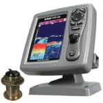
SI-TEX ColorMax Sea Link Chartplotter
$477.00
SI-TEX ColorMax Sea Link Chartplotter is a 7-inch GPS/WAAS chartplotter with an external antenna, C-MAP MAX/NT+ support, and Guardian grounding alerts. It is built for practical route management with room to expand into a broader navigation system.
Overview SI-TEX ColorMax Sea Link Chartplotter
SI-TEX ColorMax Sea Link Chartplotter is a 7-inch charting system designed for dependable navigation with a daylight-viewable active matrix LCD. The unit combines an external GPS/WAAS antenna layout with clear chart presentation and a practical control interface for everyday helm use.
An ultra-fast processor, Guardian Grounding Alarm, C-MAP MAX/NT+ compatibility, and storage for waypoints, routes, and tracks give this model useful chartplotting depth without making operation complicated. It also supports video input, second-station capability, Depth Graph input, and optional fishfinder, radar, AIS, GPS, or Loran integration.
Key Features
- 7-inch active matrix color LCD with 800 x 480 resolution supports clear chart viewing in daylight.
- External GPS/WAAS receiver supports accurate positioning for route and waypoint navigation.
- Ultra-fast processor helps keep screen changes and chart handling responsive.
- Guardian Programmable Anti-Grounding feature monitors charted hazards ahead of the vessel.
- Stores up to 1000 waypoints or marks, 50 routes, and 5000 track points for repeated navigation use.
- Video input, second-station capability, Depth Graph input, and NMEA-0183 support broaden system integration.
Applications
- Primary chart plotting on coastal and nearshore vessels.
- Helm stations that want route management plus the option to add sonar, radar, or AIS later.
- Operators who use chart-based grounding awareness, tide information, and location search tools regularly.
Specifications
| Display | 7-inch active matrix color LCD |
| Resolution | 800 x 480 |
| GPS antenna | External |
| GPS/WAAS receiver | Included |
| Chart compatibility | C-MAP MAX/NT+ |
| Memory | 1000 waypoints/marks, 50 routes, 5000 track points |
| Navigation features | Guardian Grounding Alarm, Tide Info, Find, GOTO, MOB |
| Display modes | Split-screen, North-up, Track-up |
| Connectivity | Video input, NMEA-0183 dataport |
| Construction | Weatherproof |
What’s Included
- Bracket mount
- Surface mount kit
- Protective cover
Frequently Asked Questions About SI-TEX ColorMax Sea Link Chartplotter
Who is the SI-TEX ColorMax Sea Link Chartplotter intended for on board?
SI-TEX ColorMax Sea Link Chartplotter is designed as a helm navigation display for mariners who need clear chart viewing and reliable onboard integration. Its 7-inch display and preloaded C-MAP coverage for lakes, rivers, and coastal routes support route planning and day-to-day navigation, while the stated processing platform helps keep helm use responsive.
What is this unit like in everyday navigation use?
This chartplotter centers navigation around a 7-inch display that gives chart data enough working space without overcomplicating operation. The processor is intended to keep chart browsing and panning responsive during routine navigation.
What networking support does this unit provide?
This chartplotter is intended to work within a broader electronics layout by supporting camera input support, radar connectivity where stated, and WAAS-enabled GPS positioning. This gives the display a stronger role as a central charting screen when other sensors or onboard data also need to be viewed at the helm.
Where does this unit make the most sense on board?
This chartplotter makes the most sense for helm stations that want a chartplotter focused on route work, visibility, and helm integration. Its preloaded C-MAP coverage for lakes, rivers, and coastal routes also helps reduce setup time for boats that want charting ready from the start.
Related products
Garmin GPSMAP 1022 Chartplotter
$909.00
Garmin GPSMAP 8412 Chartplotter
$2,000.00
Garmin GPSMAP 8616 Chartplotter
$3,136.00
Garmin GPSMAP 9019 Chartplotter
$7,143.00
Garmin GPSMAP 9219 Chartplotter
$6,629.00
Garmin GPSMAP 9224 Chartplotter
$8,904.00
Raymarine Axiom+ 9 Chartplotter
$756.00
Reviews
There are no reviews yet.