
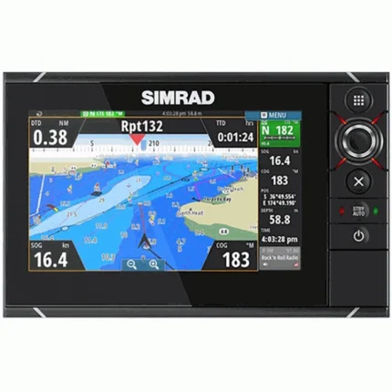
Garmin GPSMAP 7612xsv Chartplotter Fishfinder
$1,935.00
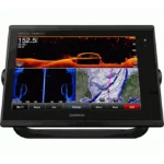
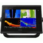
Garmin GPSMAP 7612xsv Chartplotter Fishfinder is a 12-inch chartplotter and fishfinder combo built for responsive navigation and clearer sonar views. It combines 10 Hz Internal GPS/GLONASS to support fishing and route planning from the helm. It also includes built-in CHIRP, DownVü, and SideVü sonar support.
Overview Garmin GPSMAP 7612xsv Chartplotter Fishfinder
Garmin GPSMAP 7612xsv Chartplotter Fishfinder is a 12-inch chartplotter and fishfinder combo built for responsive navigation and clearer sonar views. It combines 10 Hz Internal GPS/GLONASS to support fishing and route planning from the helm. It also includes built-in CHIRP, DownVü, and SideVü sonar support. Key onboard capabilities include 1280 x 800 pixels (WXGA), 10 Hz Internal GPS/GLONASS, Garmin Marine Network.
In practical tournament use, the SideVü scanning sonar allows captains to sweep large areas of the ocean floor to locate submerged wrecks or reefs that other anglers might miss. Because the sonar data can be shared across the entire network, the crew on the flybridge and the anglers on the deck can all view the same high-definition maritime mapping and sonar feeds simultaneously, ensuring everyone is synchronized.
Key Features
- All-in-One Sonar Capabilities: This unit features a built-in 1kW true dual CHIRP sonar, offering 8,000W peak-to-peak power for incredible depth performance and target separation.
- Scanning Sonar: Integrated CHIRP DownVü and SideVü technology provide near-photographic images of structure and fish both directly below and to the sides of your boat, making it easier than ever to locate productive fishing spots.
- 12-Inch Multi-Touch Display: The large widescreen provides ample space for split-screen views, allowing you to monitor charts, radar, and sonar data simultaneously without sacrificing legibility.
- High-Sensitivity 10 Hz GPS: With position and heading updates occurring 10 times per second, the chartplotter delivers smooth, fluid tracking that is essential for precise navigation in narrow channels or crowded harbors.
- Networking: Fully compatible with the Garmin Marine Network and NMEA 2000, this unit can interface with autopilot, radar, thermal cameras, and digital switching systems for a truly unified helm.
- Built-In Connectivity: Integrated Wi-Fi and ANT+ allow for seamless synchronization with the Garmin Helm app and BlueChart Mobile, giving you the freedom to view and control your screen from anywhere on the vessel.
Applications
Garmin GPSMAP 7612xsv Chartplotter Fishfinder-water structures and baitfish is the key to success. In practical tournament use, the SideVü scanning sonar allows captains to sweep large areas of the ocean floor to locate submerged wrecks or reefs that other anglers might miss.
Because the sonar data can be shared across the entire network, the crew on the flybridge and the anglers on the deck can all view the same high-definition maritime mapping and sonar feeds simultaneously, ensuring everyone is synchronized. For long-range cruisers and sailors, the unit provides a robust safety platform.
Specifications
| Display Size | 12.0 inches Diagonal |
| Resolution | 1280 x 800 pixels (WXGA) |
| Transmit Power | 1kW Traditional (8,000W Peak-to-Peak) |
| GPS Receiver | 10 Hz Internal GPS/GLONASS |
| Networking | Garmin Marine Network |
What’s Included
- 1x Garmin GPSMAP 7612xsv Chartplotter with Preloaded Maps
- 1x Power/Data Cable
- 1x NMEA 2000 Drop Cable
- 1x T-connector
- 1x Bail Mount with Knobs
- 1x Flush Mount Kit
- 1x Protective Cover
- 1x Product Documentation and Manual
Frequently Asked Questions About Garmin GPSMAP 7612xsv Chartplotter Fishfinder
Who is Garmin GPSMAP 7612xsv Chartplotter Fishfinder most suitable for?
Garmin GPSMAP 7612xsv Chartplotter Fishfinder is designed for responsive navigation and clearer sonar views. It combines 12.0 inches Diagonal display with All-in-One Sonar Capabilities to support navigation, fishfinding, and everyday helm decisions.
What key functions make this unit practical on the water?
This system is described with 12.0 inches Diagonal display with 1280 x 800 pixels (WXGA) resolution; All-in-One Sonar Capabilities; 12-Inch Multi-Touch Display. Those details make it easier to read navigation data and interpret underwater information during normal use.
What integration or networking support is mentioned for this chartplotter?
This chartplotter includes Garmin Marine Network; 10 Hz Internal GPS/GLONASS, which supports data sharing, position updates, or system expansion when those functions are listed for the model. That can be useful for owners who want charting, sonar, and connected onboard information working together.
How does this unit help in real on-the-water conditions?
This display is aimed at responsive navigation and clearer sonar views, so its stated feature set matches practical day-to-day navigation and fishfinding needs. The screen size and feature focus should suit operators who want charting and sonar information presented in a single helm interface.

Reviews
There are no reviews yet.