
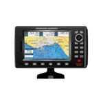
Standard Horizon CP190iNC Chartplotter
$252.00
Standard Horizon CP190iNC Chartplotter is a chartplotter designed for dependable marine use. Key features include Display 5″ TFT Color LCD, 320×240, GPS Receiver Internal WAAS 50-channel (optional external antenna), and Chart Support C-MAP NT+ / C-MAP MAX.
Overview Standard Horizon CP190iNC Chartplotter
Standard Horizon CP190iNC Chartplotter is a chartplotter with 5" TFT Color LCD, 320×240 display, networking 2x NMEA Inputs / 3x Outputs, and 5" daylight-viewable TFT color LCD (320 × 240 resolution).
Standard Horizon CP190iNC Chartplotter combines display 5" TFT Color LCD, 320×240, gps receiver Internal WAAS 50-channel (optional external antenna), chart support C-MAP NT+ / C-MAP MAX, and networking 2x NMEA Inputs / 3x Outputs. The format is well suited to helms that prioritize straightforward charting, waypoint management, and integration with compatible marine electronics.
Key Features
- 5" daylight-viewable TFT color LCD (320 × 240 resolution): Supports the core operation and integration expected from this model.
- Internal WAAS-enabled 50-channel GPS: Supports position tracking, route accuracy, and dependable navigation updates.
- Compatible with C-MAP NT+ and C-MAP MAX electronic cartography: Helps with route planning, coastal navigation, and day-to-day waypoint management.
- Dedicated MARK, ROUTE & INFO keys for fast operations: Supports the core operation and integration expected from this model.
- Dual chart window with independent zoom controls: Helps with route planning, coastal navigation, and day-to-day waypoint management.
- Satellite image overlay on basemap charting: Helps with route planning, coastal navigation, and day-to-day waypoint management.
Applications
Standard Horizon CP190iNC Chartplotter fits boats that need dedicated charting, route management, and dependable GPS guidance without unnecessary complexity. It is useful for coastal navigation, waypoint tracking, and installations where sunlight readability and straightforward controls are important.
With features such as 5" daylight-viewable TFT color LCD (320 × 240 resolution), Internal WAAS-enabled 50-channel GPS, Compatible with C-MAP NT+ and C-MAP MAX electronic cartography, and Dedicated MARK, ROUTE & INFO keys for fast operations, this model supports everyday route planning, mark management, and integration with compatible marine electronics. It works well for users upgrading an older chartplotter or refreshing a compact helm layout.
Specifications
| Display | 5" TFT Color LCD, 320×240 |
| GPS Receiver | Internal WAAS 50-channel (optional external antenna) |
| Chart Support | C-MAP NT+ / C-MAP MAX |
| Networking | 2x NMEA Inputs / 3x Outputs |
| Storage | 3000 Marks / 50 Routes / 20 Tracks / 10,000 Track Points |
| AIS / DSC | Supported (optional hardware required) |
| Fish Finder | FF525 black box compatible |
| Warranty | 2-Year Waterproof Warranty |
What’s Included
- STANDARD HORIZON CP190iNC display unit
- Swivel bracket + flush mount hardware
- Power/data cable
- User manual
Frequently Asked Questions About Standard Horizon CP190iNC Chartplotter
What does the Standard Horizon CP190iNC Chartplotter offer for everyday navigation?
Standard Horizon CP190iNC Chartplotter is designed as a helm navigation display for mariners who need clear chart viewing and reliable onboard integration. Its helm display and preloaded C-MAP coverage for lakes, rivers, and coastal routes support route planning and day-to-day navigation, while the stated processing platform helps keep helm use responsive.
How does the display support chart viewing at the helm?
This chartplotter centers navigation around a helm display that gives chart data enough working space without overcomplicating operation. The processing platform is described to keep chart browsing and menu response responsive at the helm.
What networking support does this unit provide?
This chartplotter supports WAAS-enabled GPS positioning, which helps it exchange navigation data and serve as part of a broader helm installation. That is useful when charting needs to sit alongside vessel data, shared maps, or connected marine sensors on the same system.
Who is this display most relevant for?
This chartplotter is most relevant for cruising boats and general navigation helms who need a dependable navigation screen at the helm. Its preloaded C-MAP coverage for lakes, rivers, and coastal routes also helps reduce setup time for boats that want charting ready from the start.
Related products
Garmin GPSMAP 1243 Chartplotter
$1,754.00
Garmin GPSMAP 8410 Chartplotter
$1,513.00
Garmin GPSMAP 8610 Chartplotter
$1,513.00
Garmin GPSMAP 9022 Chartplotter
$7,539.00
Garmin GPSMAP 9219 Chartplotter
$6,629.00
Garmin GPSMAP 9222 Chartplotter
$7,600.00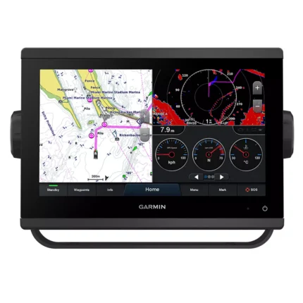
Garmin GPSMAP 923 Chartplotter
$974.00
Reviews
There are no reviews yet.