
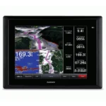
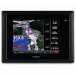
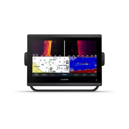
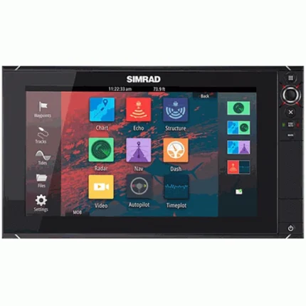
Garmin GPSMAP 820xs Chartplotter Fishfinder
$720.00
Garmin GPSMAP 820xs Chartplotter Fishfinder combines Built-in CHIRP and DownVü Scanning with an 8-inch SVGA display and integrated GPS mapping. It is built to show sonar returns, structure, and chart data together for more confident navigation and fishing decisions.
Overview Garmin GPSMAP 820xs Chartplotter Fishfinder
Garmin GPSMAP 820xs Chartplotter Fishfinder combines chartplotter and fishfinder functions in one marine unit, making it easier to read sonar returns and navigation data from the same screen. Built around an 8-inch SVGA display, the 800 x 600 Pixels display is matched with Built-in CHIRP and DownVü Scanning so the unit can support both route decisions and fishing setup.
Garmin GPSMAP 820xs Chartplotter Fishfinder is especially useful for operators who want one display to manage navigation, waypoint work, and sonar interpretation without moving between separate devices. Internal 10 Hz GPS/GLONASS; NMEA 2000, NMEA 0183, Marine Network.
Key Features
- Display clarity: Uses an 8-inch SVGA display with 800 x 600 Pixels so sonar, charts, and system data remain easier to read from the helm.
- Sonar capability: Built-in CHIRP and DownVü Scanning. Adds a tighter view below the hull for reading structure, edges, and bottom changes.
- Positioning: Internal 10 Hz GPS/GLONASS keeps chart position and waypoint updates responsive for navigation and return-to-spot accuracy.
- System integration: NMEA 2000, NMEA 0183, Marine Network allows the unit to share data with compatible marine electronics and sensors.
- Wireless support: Wi-Fi (BlueChart Mobile and Garmin Helm) expands access to compatible mobile or remote helm functions where supported.
- Mounting options: Options such as Bail, Flush, or Flat-Mount make it easier to match the installation to the console layout.
Applications
This combo unit is a practical fit for boats that need charting and sonar together on one screen without adding separate helm displays. It suits everyday navigation, fishing, and route management on inland and coastal waters where quick access to charts, waypoints, and sonar returns helps with on-water decisions.
The display size and built-in GPS mapping also make it easier to run split-screen views so operators can watch position, bottom changes, and fish targets at the same time.
Specifications
| Display Size | 8.0 Inches Diagonal (SVGA) |
| Display Resolution | 800 x 600 Pixels |
| GPS Receiver | Internal 10 Hz GPS/GLONASS |
| Sonar Technology | Built-in CHIRP and DownVü Scanning |
| Transmit Power | 1 kW Traditional / 600 W CHIRP |
| Networking | NMEA 2000, NMEA 0183, Marine Network |
| Wireless Support | Wi-Fi (BlueChart Mobile and Garmin Helm) |
| Card Slots | 2 microSD |
| Waterproof Rating | IPX7 (Waterproof) |
| Mounting Options | Bail, Flush, or Flat-Mount |
| Product Warranty | 12-Month Manufacturer Warranty |
What’s Included
- Garmin GPSMAP 820xs with worldwide basemap
- 4-pin DownVü transducer with transom and trolling motor mounts
- Power/data cable
- Bail mount and flush mount kits
- Protective front cover
- Documentation and manuals
Frequently Asked Questions About Garmin GPSMAP 820xs Chartplotter Fishfinder
What role does Garmin GPSMAP 820xs Chartplotter Fishfinder play on board?
Garmin GPSMAP 820xs Chartplotter Fishfinder is designed for boaters who need charting and sonar in one helm display. It combines 8.0 Inches Diagonal (SVGA) display with Built-in CHIRP and DownVü Scanning to support navigation, fishfinding, and everyday helm decisions.
What key functions make this unit practical on the water?
This chartplotter is described with 8.0 Inches Diagonal (SVGA) display with 800 x 600 Pixels resolution; Built-in CHIRP and DownVü Scanning; Display clarity. Those details make it easier to read navigation data and interpret underwater information during normal use.
What integration or networking support is mentioned for this chartplotter?
This display includes NMEA 2000, NMEA 0183, Marine Network; Internal 10 Hz GPS/GLONASS, which supports data sharing, position updates, or system expansion when those functions are listed for the model. That can be useful for owners who want charting, sonar, and connected onboard information working together.
How does this unit support day-to-day visibility and control?
This unit is described for active marine use, where clear visibility, responsive operation, and straightforward access to key data matter throughout the day. The listed IPX7 (Waterproof) supports easier viewing and more confident operation in changing marine conditions.

Reviews
There are no reviews yet.