
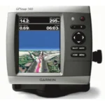
Garmin GPSMAP 541 GPS Chartplotter
$288.00
Garmin GPSMAP 541 GPS Chartplotter is a 5-inch color chartplotter with preloaded BlueChart g2 coastal coverage, worldwide basemap, and NMEA 2000 connectivity.
Overview Garmin GPSMAP 541 GPS Chartplotter
Garmin GPSMAP 541 GPS Chartplotter is designed for clear, straightforward marine navigation with a large 5-inch QVGA display and a high-sensitivity internal GPS receiver. It comes preloaded with BlueChart g2 marine cartography for the coastal United States, including Alaska, Hawaii, and the Bahamas, along with a worldwide basemap.
The unit is intended for boaters who want a dedicated chartplotter in a compact footprint. Optional BlueChart g2 Vision cards add 3D views, aerial reference photos, and Auto Guidance, while NMEA 2000 support helps it fit into compatible onboard electronics systems.
Key Features
- 5-inch ultra-bright display: Over 800 nits of brightness helps maintain visibility in bright conditions.
- Preloaded BlueChart g2 coastal mapping: Supports U.S. coastal navigation right out of the box.
- Worldwide basemap included: Adds broader chart reference beyond the preloaded coastal coverage.
- High-sensitivity internal GPS: Supports dependable position fixing without extra GPS hardware.
- BlueChart g2 Vision compatible: Optional cards add richer chart views and Auto Guidance.
Applications
A practical option for coastal boats that want a dedicated GPS chartplotter with preloaded mapping and a simple interface. The worldwide basemap also makes it useful for general reference when operating beyond the preloaded area.
It works well on smaller helms where a compact chartplotter is preferred over a larger network display.
Specifications
| Product type | GPS chartplotter |
| Display | 5-inch QVGA display, 234 x 320 pixels, over 800 nits brightness |
| GPS | High-sensitivity internal GPS receiver |
| Mapping | Preloaded BlueChart g2 coastal U.S. mapping plus worldwide basemap |
| Expansion | Single SD memory card slot with BlueChart g2 Vision support |
| Networking | NMEA 2000 certified |
What’s Included
Package contents were not clearly specified in the source data.
Frequently Asked Questions About Garmin GPSMAP 541 GPS Chartplotter
What does the Garmin GPSMAP 541 GPS Chartplotter offer for everyday navigation?
Garmin GPSMAP 541 GPS Chartplotter is designed as a helm navigation display for mariners who need clear chart viewing and reliable onboard integration. Its 5-inch display with 234 x 320 pixels and preloaded BlueChart g2 coverage for the USA and Bahamas support route planning and day-to-day navigation, while the stated processing platform helps keep helm.
How does this chartplotter handle screen readability and speed?
This chartplotter centers navigation around a 5-inch display with 234 x 320 pixels that gives chart data enough working space without overcomplicating operation. The processing platform is described to keep chart browsing and menu response responsive at the helm.
Can this display work as part of a wider helm system?
This chartplotter is intended to work within a broader electronics layout by supporting NMEA 2000. This gives the display a stronger role as a central charting screen when other sensors or onboard data also need to be viewed at the helm.
Who is this display most relevant for?
This chartplotter is most relevant for cruising boats and general navigation helms who need a dependable navigation screen at the helm. Its preloaded BlueChart g2 coverage for the USA and Bahamas also helps reduce setup time for boats that want charting ready from the start.
Related products
Garmin GPSMAP 1243 Chartplotter
$1,754.00
Garmin GPSMAP 8410 Chartplotter
$1,513.00
Garmin GPSMAP 8616 Chartplotter
$3,136.00
Garmin GPSMAP 9019 Chartplotter
$7,143.00
Garmin GPSMAP 9022 Chartplotter
$7,539.00
Raymarine Axiom+ 9 Chartplotter
$756.00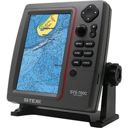
SI-TEX SVS-760C Chartplotter
$396.00
Reviews
There are no reviews yet.